TitleBloomfield Blossoms: p. 050-051 Date1976 SubjectBloomfield Hills Mastodon DescriptionCHARLIE COME HOME
This year, as we're celebrating our 200th birthday as a
Nation, it's been sugges... View Details
TitleBloomfield Blossoms: p. 052-053 Date1976 SubjectFish, Fannie DescriptionAMERICAN INDIAN INHABITANTS
Fannie Fish, in 1888, presented a paper before the
Oakland County Pion... View Details
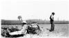
TitleAda and Bill Glawe plant rhubarb Datec. 1930 SubjectSterling Heights (Mich.)--History--Farms--Glawe Farm DescriptionAda Doebler Glawe (1888 - 1987) sits in a planting machine with bushels of rhubarb shoots to plant. ... View Details
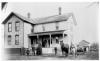
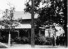
TitleFred and Catherine Hacker house Datec. 1895 SubjectSterling Heights (Mich.)--History--Dwellings DescriptionHacker farmhouse, located on northeast corner of 16 Mile Road and Mound Road. May be Fred Hacker (18... View Details
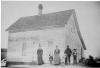
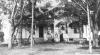
TitleMarotz Family in front of their homestead Datec. 1900-1905 SubjectSterling Heights (Mich.)--History--Marotz Family DescriptionMarotz Family stands in front of their saltbox style home located on Clinton River Rd., in winter. A... View Details
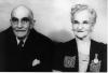
TitleAugust and Wilhelmina Marotz Datec.1945 SubjectSterling Heights (Mich.)--History--Marotz Family DescriptionPortrait (head and shoulders) of August Marotz (1867 - 1950) and his wife Wilhelmina Fischer Marotz ... View Details
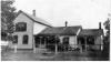
TitleBower - Hacker House Date1939 SubjectSterling Heights (Mich.)--History--Bower Family DescriptionBower - Hacker house was on 16 Mile Rd. between Ryan Rd. and Mound Rd. (5033 16 Mile Rd.). The house... View Details
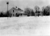
TitleHolzhauer house in winter Datec.1910 SubjectSterling Heights (Mich.)--History--Holzhauer family DescriptionHolzhauer home seen from the road (Utica Road west of Kleino Road), ground covered with snow. Tall b... View Details
TitleKarr Log Cabin Datec.1905 SubjectSterling Heights (Mich.)--History--Dwellings DescriptionKarr log cabin, located on 19 Mile Rd. at Goldberg. Home of Frederick Karr (1835-1905) and Frederick... View Details
TitleJohn B. Wright House Datec.1910 SubjectSterling Heights (Mich.)--History--Farms--Wright Farm DescriptionJohn B. Wright (1834 - 1904) lived here on Clinton River Road, north of 19 Mile Road, with his wife ... View Details
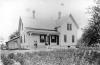
TitleAhrens Farmhouse 1918 Date1918 SubjectSterling Heights (Mich.)--History--Ahrens Family DescriptionFarmhouse located on the south side of Clinton River Rd., just west of Hayes Rd. Four people stand i... View Details
TitleAhrens Homestead Date1889 SubjectSterling Heights (Mich.)--History--Ahrens Family DescriptionAhrens family home, located on the south side of Clinton River Rd., just west of Hayes Rd. Charles A... View Details
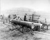
TitleChris Hacker watches as logs are cut Date1951 SubjectSterling Heights (Mich.)--History--Sawmills DescriptionHacker Sawmill on 16 Mile Road between Ryan Road and Mound Road. Chris Hacker (1888 - 1962) watches,... View Details
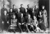
TitleChristopher Weier Family Datec.1902 SubjectSterling Heights (Mich.)--History--Weier Family DescriptionStudio portrait of family of Christopher Weier (1840 - 1929) and Pauline Reifter Weier (1849 - ?). T... View Details
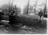
TitleHacker Sawmill Date1930-1940 SubjectSterling Heights (Mich.)--History--Sawmills DescriptionUnidentified man and boy sit on large log as it rests on truck. View Details
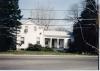
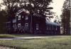
TitleBeck House Date1980-1989 SubjectSterling Heights (Mich.)--History--Farms--Beck Farm DescriptionBeck House, being used as an office for Master Fence Company. Dodge Park Road, south of Plumbrook Rd... View Details
TitleThe Book on Commerce Date1984 SubjectCommerce Township (Mich.) -- History DescriptionBooklet, 40 p., ill., maps. View Details
TitleAhrens homestead and family Datec.1908 SubjectSterling Heights (Mich.)--History--Ahrens Family DescriptionAhrens farmhouse, Clinton River Rd., west of Hayes Rd. Family lines up in front. From left: First th... View Details
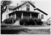
TitleHaff Farmhouse 1983 Date1983-4 SubjectSterling Heights (Mich.)--History--Farms--Haff Farm DescriptionHaff farmhouse in the Spring. Close-up of house on Dequindre Road south of M-59. View Details
TitleIsabella County Newspaper Obituary Index Date1980-2004 SubjectObituaries -- Michigan -- Isabella County -- Indexes DescriptionObituary Index: 1875 - present. Obituary sources include the following Isabella County Newspapers: ... View Details
TitleCommerce United Methodist Church Date1986 SubjectCommerce (Mich. : Township) -- Church buildings DescriptionBooklet commemorating the dedication of the Commerce United Methodist Church as an official State of... View Details
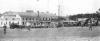
TitleBaseball Game Outside Barry's Dance Hall, Cedar Island Lake Datec.1930 SubjectCommerce (Mich. : Township) -- History DescriptionBlack and white photograph showing baseball game in progress outside Barry's Dance Hall at Cedar Isl... View Details
TitleInterior of the Cork Lane Shoe Shop Date1962-10-16 SubjectBusinesses Kalamazoo Michigan DescriptionB/W negative showing the interior of the Cork Lane Shoe Shop located at 1012 East Cork within the Co... View Details
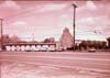
TitleMilwood Methodist Church Date1962-10-16 SubjectReligious Institutions Kalamazoo Michigan DescriptionB/W negative of the Milwood Methodist Church located at 3919 Portage Street in Kalamazoo, Michigan. ... View Details
TitleOur Lady of Czestochowa convent Datec.1980 SubjectSterling Heights (Mich.)--History--Our Lady of Czestochowa Church DescriptionFarmhouse located on the south side of 18 Mile Rd. between Dequindre Rd. and Ryan Rd., being used as... View Details
The Making
of Modern Michigan was funded by the Institute
for Museum and Library Services, an independent federal agency
that supports the nation's museums and libraries. Through agreement, this site is hosted by the MSU Libraries and therefore is subject to its privacy statement.
Please feel free to send any comments regarding this site to digital@mail.lib.msu.edu.